
We have had the good fortune to cross paths with our former real estate appraiser from Arkansas (now retired) and have been visiting back and forth with them, either going out to eat a couple times a week, or going with them on day trips in their nice new quad-cab 4WD pickup. Without that vehicle we wouldn't even have gotten in to see some of the places we have seen! Since our van was still packed full to the top of the seats, we appreciate them inviting us along on their outings!
Our first outing, a few weeks ago, was to follow Old Route 66 from Kingman to Oatman, AZ through the Black Mountains. We had been to Oatman before, in the summer of 1994, as a side-trip on our way to Portland, only we came in from the west that time. We also drove the road between there and Kingman at that time, using our compact tow car.
The road itself is a narrow 2-lane, has a lot of twists, turns, ups and downs, and sharp drop-offs with no guard rails, typical of remote mountain roads. There was a sign that indicated there was a length limit for RV's (the state says 40 feet). They seem to get through it without a problem. Still, I wouldn't take anything over 32 feet in length on that road, just for safety's sake. Still, commercial tour buses 40-feet or under have been known to navigate the road just fine.
Although the road traverses through Kingman all the way from Seligman on the east side, the part that starts into the Black Mountains west of Kingman is about ten miles out. The maps say it is 28.5 miles from the Power House Visitor Center at Kingman to Oatman.
Our friends are avid rock hounds, so a few miles before Cool Springs we pulled off the highway and down a one-lane dirt path for a few hundred feet. They were wanting to look for red (fire) agate, but only found a few wild burros and a few cacti in their early stages of blooming. The burros were actually captured with our friend's camera, but it was my finger on the shutter while checking out her 50X zoom on her camera, so I don't think she'll mind my "borrowing" it.
 |
| Wild burros near Cool Springs, AZ. Photo courtesy of Jean Green. |
 |
| Wild prickly pear cacti in bloom. |
At one time it was the last fuel and food station before heading into the mountains, and has become a museum. Right now it is closed and lacking a proprietor, therefore the search for a new owner. But be aware there's nothing out there beyond that for approximately 20 miles, so make sure you top your tank off in Kingman, before starting out. And take plenty of water. "This" 20 miles is NOT a 20-minute drive!
 |
| Museum and movie site for sale at Cool Springs, AZ, west of Kingman on Old Route 66. |
 |
| Sandstone formations on Old Route 66 west of Cool Springs, AZ. |
 |
| The sandstone formation west of Cool Springs, AZ on Old Route 66. |
 |
| A black wild burro is in the lower left of the photo. |
Finally, we topped out at Sitgreaves Pass, elevation 3550 feet (although some maps say it's 3652 feet, possibly at the top of the mountain itself). From here, we could see not only most of the direction from which we had come, but also all the way down to Oatman, several miles ahead yet.
 |
| Sitgreaves Pass, 3550 feet elevation, on Old Route 66 between Kingman and Oatman. |
 |
| Hair pin turns going down to Oatman from Sitgreaves Pass. |
Near the top of the pass were several memorial markers, some quite recent. Rather than interment in the hard rocky ground, we figure that some people wanted their ashes scattered near this beautiful location, and their friends and family have memorialized them here.
 |
| One of the memorials at the top of Sitgreaves Pass, east of Oatman, AZ on Old Route 66. |
In the distance, just past the large area of mining tailings is Oatman. The mining tailings are the waste generated by the mining operations in the area. We stopped at one old mine close to the highway. The top of this one had collapsed many years ago and has been locked off, but you can still see a little bit over the gate.
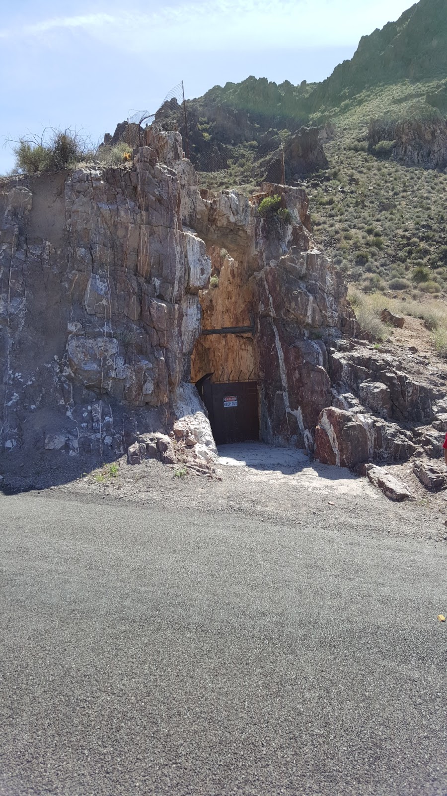 |
| An old mine entrance collapsed east of Oatman, AZ |
 |
| The path of the mine shaft before it collapsed. |
 |
| Some of the support timbers still in place. |
Another one across the road is an actual vertical shaft that has been covered over so no one falls into it. Many of these shafts can be hundreds of feet deep. There are many mines like this dotting the area. Some have been caved in, while others have been preserved for a possible future use again. And there are some that are still active, although none have been reported as producing anything significant. Some people interested in geology stay involved with mining as a hobby, more than anything else.
 |
| A covered mine shaft east of Oatman, AZ on Old Route 66. |
 |
| Memorials on a small hill east of Oatman, AZ on Old Route 66. |
 |
| A few of the wild burros wandering around Oatman, AZ. |
The city of Oatman is located at an elevation of 2710 feet. It began as a tent camp, until two prospectors struck a ten million dollar gold find in 1915. The population grew to more than 3500 people in the course of a year. However, after the mines played out, the people left and the official 2000 census lists the town as having 128 people.
Oatman was named in the posthumous honor of Olive Oatman, a young Illinois girl who was taken captive by (presumably) the Yavapai Indians and forced to work as a slave. She was later traded to the Mohave Indians, who adopted her as a daughter and had her face tattooed in the custom of the tribe. She was released in 1855 near the current site of the town. (Ref. Oatman, AZ, on Wikipedia.com for more).
Looking the other direction, you see just one main street, a lot of people, and a few more burros. There are other side streets, all unpaved, and mostly hilly, with a few scattered ramshackle houses.
 |
| The main street (Old Route 66) through Oatman, AZ. |
 |
| A 2-seater trike with a rear cargo deck! Nice fair weather touring vehicle! |
It seems every business is a tourist trap of one kind or another. If not for the tourist business, the buildings in the town would resemble a ghost town, but the main street is very much alive with action, including mock gunfights.
We finished a very delicious lunch next to the Oatman Hotel just in time to catch one of the gunfights in action. The Oatman Hotel, by the way, is where you can view the (upstairs) honeymoon suite of Clarke Gable and Carole Lombard. They were married here on March 18, 1939. Believe me, it wasn't much compared to today's standards... or even the standards of the 30's and 40's! Remember, it was probably a hundred years old already at the time they were there! But Clark had been here before, fell in love with the area, and returned often to play poker with the miners.
The other celebrity is "Oatie the Ghost", promoted as a friendly poltergeist whose identity is believed to be that of William Ray Flour, an Irish miner who died in the hotel, presumably from excessive alcohol consumption. Flour's body wasn't discovered until two days after his death, and was hurriedly buried in a shallow grave near where he was found.
Anyway, at the south end of the street were the bad guys... giving a lot of lip to the Marshall...
 |
| The bad guys of the gunfight at Oatman, AZ. |
 |
| The Marshall, in the gunfight at Oatman, AZ |
In the end, one bad guy was gunned down in the street and other one ran away. Of course, they all walked away to fight another day, and mingled with the crowd for autographs!
The burros were totally unimpressed and wanted to go shopping, rather than listen to the extremely loud six guns!
 |
| Sweet Alice checking out one of the souvenir shops! |
On the way home, we got some different perspectives of some of the hills and curves we had come around on the way up there.
 |
| One of the hills with switchbacks east of Oatman, AZ. |
Upon heading toward our "base", we happened to be on time to see one of the many freight trains rolling along side Old Route 66. Notice the five engines it takes to get these trains through some of the mountains!
 |
| One of many freight trains with a lot of engines for the mountain grades! |
 |
| Some long trains even have engines at the back end to help push them up the grades! |
We were a little too late for any early-bird specials at the local restaurants, but we still grabbed a nice dinner at a local restaurant with our friends, and then rushed home to our Angel, waiting patiently at the trailer... legs crossed, jumping up and down, leash in his mouth. (Just kidding). He actually slows down his metabolism by sleeping most of the day, so he does pretty well, but we try to never leave him for more than 6 hours at a time. And it was cool that day. We left both ceiling vents open and all the windows open, so he was getting a lot of fresh air! We would never leave him anywhere that would become too hot before we could return.
Next up (in the next post) is another little side trip we made out to Chloride, including down a Jeep road east of Chloride to see some famous artwork on the sides of mountain rocks, and then up into some VERY steep terrain to the top of a mountain north of town. Had it not been for our friends and their 4WD truck, we would have never found, let alone seen these places! If you don't know anything about Chloride, you owe it to yourself to Google it and do some research on it. Don't forget to check out Google images on a link at the top of the search results. You'll see some very interesting pictures, many of which we were not able to get. And then come back to this blog for an update.
Thanks for hanging in there with us. We'll try to have more travel posts in the future and not as much on our vehicles or daily tasks. And thanks for making your Amazon purchases through our links. Every little bit we get from Amazon helps our quest to bring you more of these kinds of posts.
As always, let us know what you are thinking. Surely, out of roughly 3,000 people reading this blog every month, some of you must have something to say. Please share it!
No comments:
Post a Comment
We welcome conversational comments that are on topic and useful. Links to personal blogs are fine, but we will not approve comments made for the sole purpose of linking to a commercial business, and/or which have no direct relevancy to the topic of the post. Thank you.
Only those who have Google accounts may comment, as the platform has done away with the "Open ID" concept.