
Getting rid of the minivan was a necessary move, and with it gone, we "could" have moved on, except for the fact that we had already paid a month in advance. That, and the fact that the temperatures were still dropping to below freezing in the areas that we wanted to move on to, That prevented us from going farther east, so we stayed put. The park was very nice... probably the nicest KOA that we have ever stayed at. We were given a full hook-up site right across from the south restrooms and pool area, and had usable WI-FI most of the time.
 |
| Our trailer and conversion van at the Kingman KOA. |
This KOA is right in town, just a few blocks from any shopping and restaurants we could want, although we still tried to limit our outings to once a week, except when we went places with friends. We got in the habit of hitting Taco Tuesday at Del Taco (3 tacos for $1.29 after 4 PM), and often went back for second orders! On Thursdays we would usually go to the Golden Corral for their early bird special ($7.59 w/senior discount) for all you can eat from several different food bars. We would get there around 3:30 and get a light start, and then at 4 PM, they would start grilling steaks to order! We would always leave very "over" stuffed, but that was our once a week treat to ourselves for eating light most of the other nights.
We also went with friends to the little town of Oatman, which I wrote about in the previous post. Another time, they drove us a little farther north to Chloride, which is what this post is about. This is a small interesting mining town just east of Hwy 93, and just across the mountains from Kingman to the northwest. There is an RV park there that we had briefly discussed moving to for April, but due to changes in our friends schedule, we decided to stay at the KOA through most of April.
Chloride is a very unusual town, steeped in history... and artwork... lots of artwork! Some is very good, and some is nothing more than a collection of junk, but all interesting in its own way.
 |
| The fence at the cattle gate... the entry point into Chloride. |
Chloride is a one time silver mining camp in Mohave County, Arizona, and is considered the oldest continuously inhabited mining town in the state. In 2000, the population was 352, although there was a time that it was much more than that.
From Wikipedia: "Chloride is located on the southwest flank of the Cerbat Mountains northwest of Kingman, Arizona. Grasshopper Junction is four miles to the west on US Route 93." (Although that is about all it is... a junction of two roads.)
"Prospectors first located mineral resources in the area in the 1840s, including silver, gold, lead, zinc, and turquoise. Chloride was founded about 1863, but mining was not widespread until the 1870s after a treaty was signed with the Hualapai Indians. The railway from Kingman, called the Arizona and Utah Railway, was inaugurated on August 16, 1899 - the last silver spike was driven by Miss May Krider. The town eventually grew to a peak of around 5,000 inhabitants, and at one time Chloride was the county seat. By 1917 the population had fallen to 2,000, and by 1944 it was nearly a ghost town.
American author Louis L'Amour visited Chloride sometime between 1927 and 1929 after the Weepah, Nevada goldrush, where he had bought, and then sold, a claim for $50. During his visit the town of Chloride caught fire. L'amour assisted the town citizens in a bucket brigade that ultimately failed to stop most of the town from burning to the ground."
You can find a great panoramic photo of the city and mountains, as well as much more information, on the Wiki page at https://en.wikipedia.org/wiki/Chloride,_Arizona.
At the east end of Main Street, after the pavement ended, our friend in his 4WD Dodge quad cab kept on driving... down a road that I would not have gone with that vehicle! It was better suited to a vehicle with much higher ground clearance! But they were determined to show us something that we would not have seen otherwise.
A couple miles down that road it starts into the mountains before coming to a dead end... at least for normal vehicles. At the turn-around point, we were amazed at what was out there in the middle of nowhere!
 |
| The Roy Purcell artwork, towering nearly a hundred feet high, entitled "The Journey". |
(Curiously, in Kingman, the KOA campground is called the "KOA Journey" as well as a local church having the word "Journey" in it. Whether there is a connection to the paintings remains to be researched! Maybe someone out there knows!)
"The colors Purcell used to paint his murals are remarkably vivid and have withstood harsh desert weather for nearly four decades. Stone carvings and etchings from earlier Indian artists can also be seen in the immediate area." (source: http://www.roadtripamerica.com/places/chloride.htm)
 |
| There was a prophetical message about mining in his painting. |
 |
| Some of the paintings showed great detail, and yet the message remained vague. |
 |
| You could see all the way back to Chloride from the mountain. |
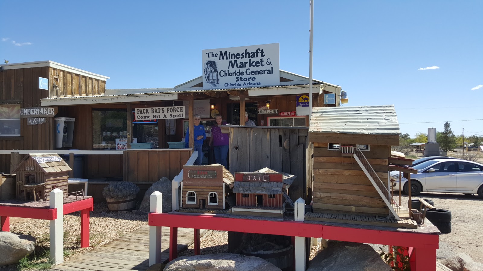 |
| The Mineshaft Mercantile, with many hand-made miniature buildings around it. |
 |
| Behind this sign was a pit toilet building. Primitive campsites were in the brush on both sides of the road. |
Well, it was "almost" at the top. We could have continued another mile and a half to the "very" top, at Windy Point Recreation Site. But we weren't sure our stomachs could take another mile of gravel switchbacks overlooking sheer drop offs!
 |
| The road continued for another 1.5 miles to Windy Point, but we stopped here and turned around. |
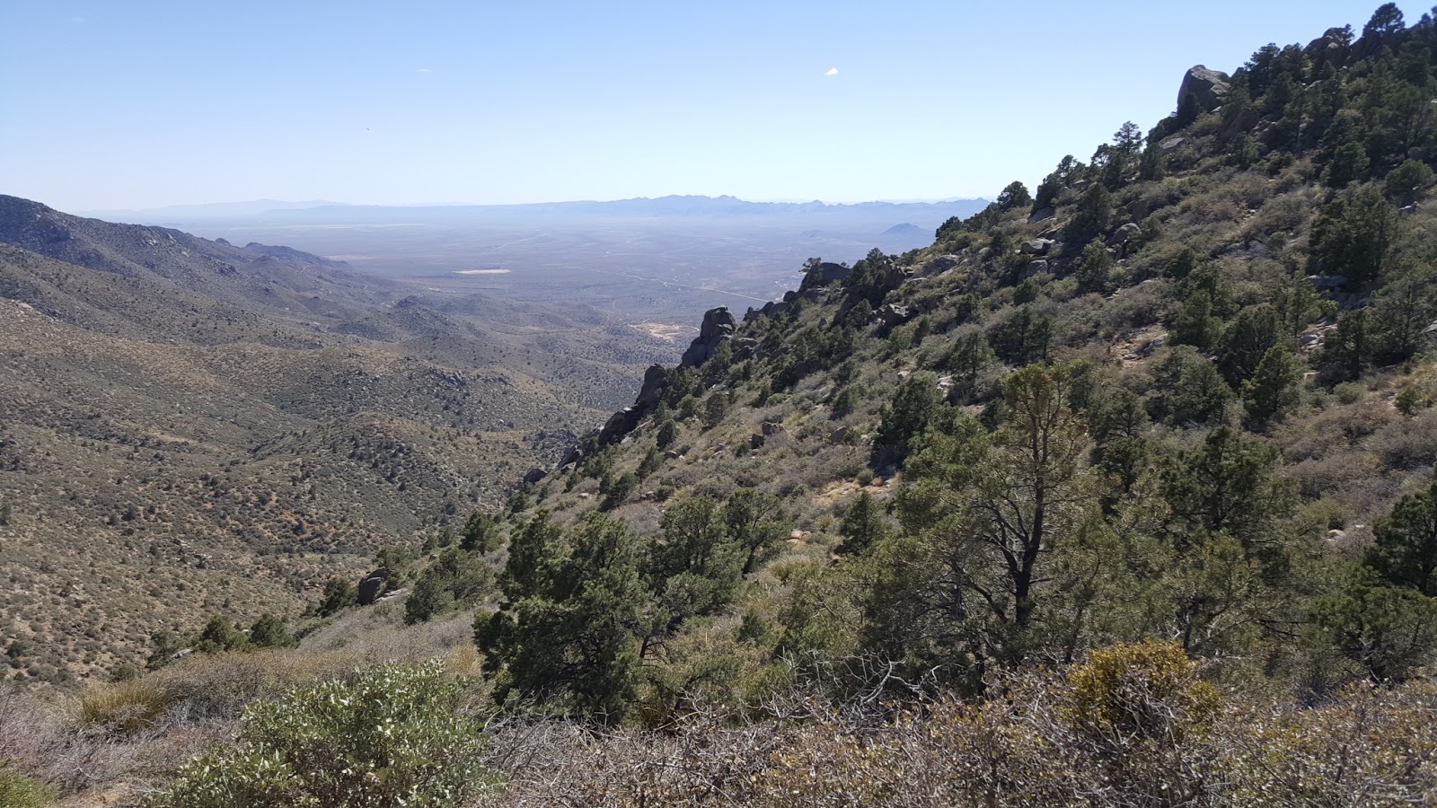 |
| From just beyond the Windy Point sign you could see all the way to Kingman! |
From the BLM.gov site at http://www.blm.gov/az/st/en/prog/recreation/camping/dev_camps/packwind.html: "Packsaddle and Windy Point Recreation Sites are situated two miles apart along the crest of the Cerbat Mountains, high above the old mining town of Chloride, Arizona. Located at a 6,000 foot elevation, these recreation sites are located in a picturesque woodland consisting of pinyon pine and juniper. Visitors here are treated to spectacular views of the surrounding valley and distant mountain ranges."
Due to the elevation, be aware that even in the summer it can get very cold up there at night. Even during the spring day when we were up there, it was in the upper 80's in Chloride, and yet was about 25 degrees cooler up on the mountain... and that was during the daytime! At night it could easily be down into the teens!
After looking around and taking a few photos, we headed back down the same way we came... in 4WD low!
 |
| This was one of the better (and more level) parts of the road! |
The 2010 census shows it having a little over 2000 people, but it covers an area of 28.6 square miles! The main road is where most businesses are located, and it stretches out for several miles. Just east of it you enter into a beautiful valley full of Joshua trees. They aren't quite as thick as the forest along Hwy 93 north of Wickenburg, but equally as beautiful in their own right. One of the largest ones we have ever seen is right along the highway on the south side east of town.
Farther east, we eventually came to the intersection where Stockton Hill Road, the main north/south street through Kingman, comes to its northern terminus. That point is actually about 36 miles north of Kingman. The highway goes through much open farm land surrounded by mountains on both sides before entering the city from the north.
For more photos of this trip and others, don't forget to check out Sharon's blog. She often gets photos with her camera that I miss, and often has a different story to tell. You can find a link to her blog in the upper right corner, in the margin.
At this point it was nearly dinner time again, and our friends knew about a special at Popeye's Chicken. In reality, we probably wouldn't even have found the place, as it's located in the Travel America truck stop at the west edge of Kingman on Old Route 66, with barely a sign visible. They knew that Popeye's had an unadvertised 2-piece, 2-sides box for $5... and it isn't on the menu! We had to ask for it! Our friends have been coming to this area since 1989 and have had a lot more time than we have to scout out the good buys! But we're taking mental notes!
We had planned to leave the Kingman KOA on April 25th, but due to high wind advisories, we delayed until the 26th. There were some nasty storms moving through the area, with winds gusting to over 50 mph.
 |
| Cold gray clouds brought wind to us and snow to higher elevations. |
We could have stopped at any number of RV parks or boondocking spots along Hwy 60 toward Wickenburg, but since we are Escapees members now, we decided to go a few miles out of our way and stop at The Escapees North Ranch in Congress, AZ. Since we are set up for it, we chose a dry camping site for a couple of days. Only one catch... they have a rule against generator usage in the resort, so we were still unable to try out our newly repaired generator! Darn! I wish now that we could have run it before getting so far away! But we can get by for a few days without 120-volt power. And if we got desperate, we could always run a cord from the 2000-watt inverter in the trailer.
 |
| Our trailer and RV in the dry camping area at Escapees North Ranch at Congress, AZ. |
 |
| Double yucca plants dwarf the RV next to them! |
 |
| This single yucca was probably a different species, with HUGE leaves! |
On the way to our next stop, we pulled over to have some lunch, and discovered the generator would now run very nicely, but we had no power to the receptacle where the coach plugs into it! I checked all the breakers I could find and reset them, and still nothing. This is very curious because it worked fine when we were at the dealership! I had run the microwave and air conditioner myself, while the mechanic ran the generator, and they worked great! So now I have some more troubleshooting to do while we are here. It's probably something simple.
Our current stop is at another private residence, so we won't write about that until after we leave here, probably sometime late next week. They were/are (her husband has since passed) long time RV friends, and have full hookups from the 5th-wheel they used to own. We haven't seen them for several years, so it will be good to visit again and play "catch up". From here, we will continue toward New Mexico, where we will explore about 50 miles in every direction around Albuquerque for about a month before continuing on to Texas to get our vehicle tags and driver's licenses up to date. Then it will be back toward the mountains again for the rest of the summer, and cooler, dryer air!
We will continue to update our adventures with new posts as we go along, but for privacy, they will always be a week or two behind. As always, we appreciate those of you who use our links to make purchases on Amazon. It doesn't cost you any more to do so, and Amazon provides us with a small token of their appreciation, which at this point, is going toward repairs and improvements on this RV, as well as some traveling expenses.
Until next time... Stay well and travel safe.
Some neat places to visit, John. Thanks for your descriptions and alerts/warnings about road conditions and the dangers of taking vehicles with low ground clearance. My van has pretty high clearance, but I'll still probably not take it to some of these sites.
ReplyDeleteLf&bh,
Ed
Hi Ed! On the road to Packsaddle RA, it might be possible to take a 2WD vehicle as long as it's dry, but I wouldn't recommend it on a rainy day. There was just too much loose gravel on some of the steep slopes. It's always a good idea to check with local field offices, as the rangers regularly travel such roads and can give specific information on the conditions. Topographical maps are good to tell you about changes in elevation, but even they can't tell you about things like loose gravel or soil content. The main thing is not to trust campground directories simply based on location or directions. They may not tell you that paved roads are full of potholes, or are only one vehicle wide in places, or unpaved could mean clay that gets slick when it gets wet, or that gravel is like a washboard, or that some places may have washed out with the last rain, or that some places may be an 11% grade on loose stones! First-hand and recent knowledge by those who drive the roads regularly is always the best kind! Stay well and travel safe!
Delete